By Ryan Matthey ▪
LAS VEGAS (KLAS) — From Pahrump to Las Vegas, to Red Rock Canyon the Nevada Department of Transportation (NDOT) said those commutes need safety improvements.
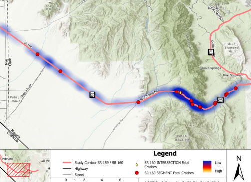
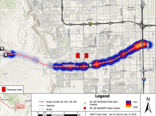
NDOT released its SR-160 & SR-159 corridor plan this month, which highlighted changes to the two highways it intends to pursue in the coming years following an uptick in fatal vehicle collisions along them. It also examined traffic data from 2015 to 2019 as part of it.
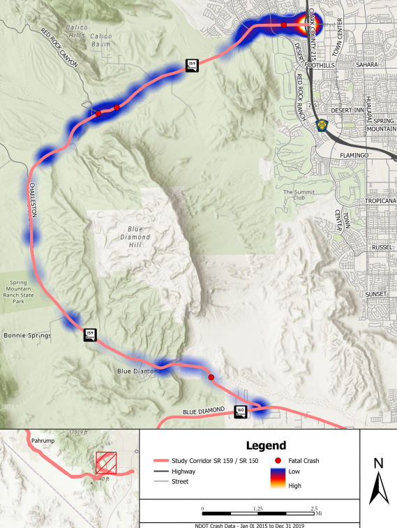
Within that data pinpoints the areas within the 80-mile project most prone to these crashes. 32 fatal crashes and 35 fatalities were recorded within the project’s scope over the five-year period.
Those areas could see more traffic and speed control, roundabout installations, raised medians, widened streets, and bike lanes with buffers from traffic.
Heather Fisher is president of Save Red Rock, a nonprofit that works to preserve and protect Red Rock Canyon and its recreation. She and other members were some of the hundreds who submitted public input since the project kicked off in January 2022.
“We’ve been just trying really hard to make sure that the visitors that come to red rock can feel safe and be safe,” Fisher said during a virtual interview Wednesday evening.
Both NDOT and Fisher said the highways have become more dangerous and busier in recent decades as Southern Nevada’s population boomed. The construction and developments that followed along these highways have brought more drivers, pedestrians, and bikers to areas where these fatal collisions were recorded.
That is part of the reason some are in opposition to certain aspects of the project. Specific to SR-159, NDOT said hundreds of bikers travel close to traffic every week, on top of the thousands of visitors there to hike.
To John Hegyes, a frequent Red Rock Canyon climber, the increased marketing of the area as a recreation destination has given way to increased road dangers. More visitors and traffic, yield higher needs for traffic control that forces drives to stop, which he believes could inversely worsen safety.
He also feels it is redundant to spend money on improving the bike lanes when the Red Rock Legacy Trail paved bike path is already planned to be built alongside the highway.
“Our access is being curtailed,” Hegyes said outside the 8 News Now station Wednesday evening. “The people that run these companies, they’re also really pushing for more barriers with more toll booths, fees, and reservations.”
“I don’t think we can say, ‘everybody stop coming to Red Rock.’ I just don’t think that’s going to happen. So, if we can just make it more organized, I think that will help with safety,” Fisher said.
The project has yet to receive the green light, however. The corridor plan cites the state department still needs to identify funding sources, with a price tag that could reach over $350 million.
Public comment on the proposed changes will be accepted until February 24, via info@ndotsr160.com or on the project’s website.