As the trail opens, a calendar of upcoming events will be available here.
Each phase of the project has its own funding, design, and construction schedules, with each phase following a similar process spanning initial planning to final implementation and construction. Here is an overview of the current status per each phase:
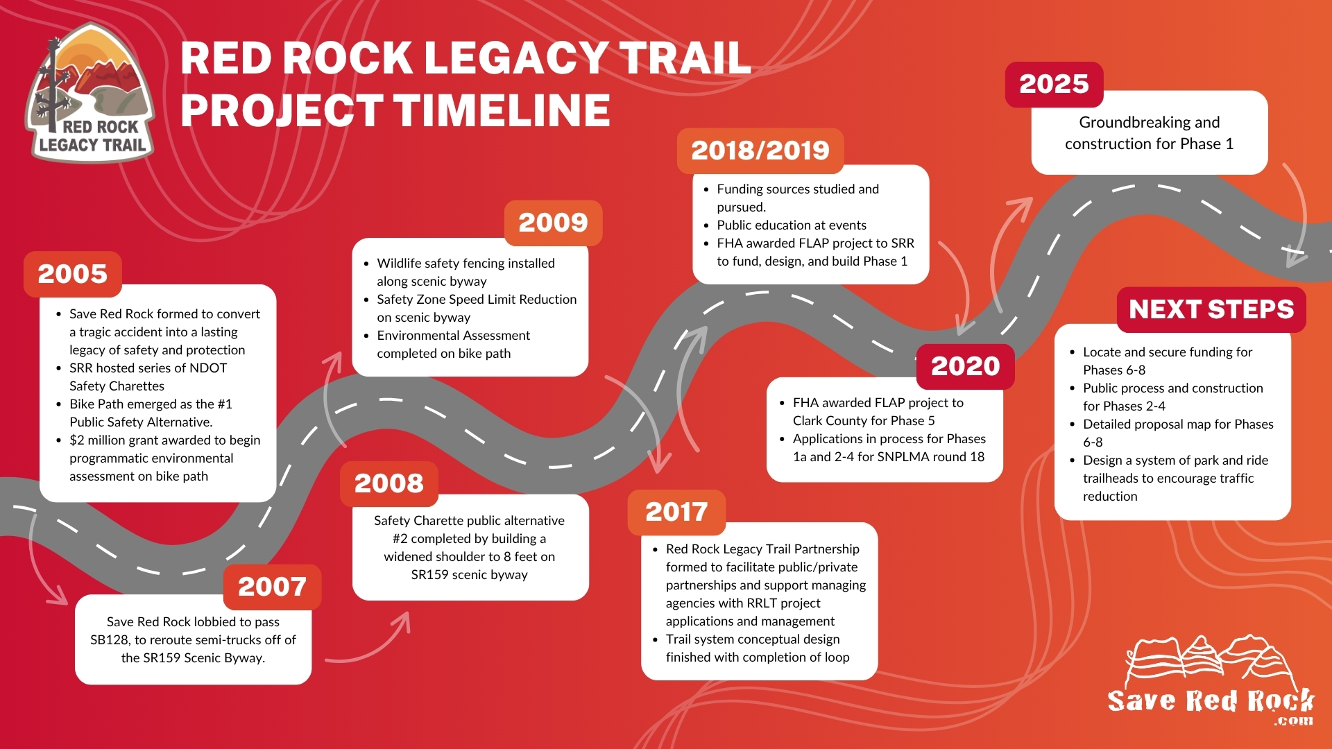
July 2025 | Groundbreaking and construction for Phase 1
Phases 2-5 | These phases are in the early stages of planning and design. Specific construction timing will be announced as efforts progress.
Stay tuned for updates as we move forward!
Tuesday, February 20, 2024 | Red Rock Legacy Trail Open House
April 7 – May 9, 2022 | BLM Public Comment Period for Red Rock Legacy Trail, Phase One
August 2021 | Final project design completed for potential groundbreaking late 2021 for Phase 1. Estimated completion is one year from construction start.
February 2020 | Clark County Commission approved matching funding for the northern portion of the trail, Phase 1, from Sky Vista in Summerlin to the Red Rock Canyon Visitor’s Center. In March, Commissioner Justin Jones’ Brandon Munson office worked with Save Red Rock to apply for Phase 5. This portion of the trail in his district, extends from Mountain’s Edge to the town of Blue Diamond. Meanwhile, teams of cultural, biological, and soil scientists conducted field work on the environmental surveys and alignments of Phase 1. Subsequent studies are in process and public meetings are tentatively scheduled for winter 2020 (health circumstances-permitting). In May, Clark County Commissioners unanimously approved the application for Phase 5, and in June, the project was awarded to the County by FLAP. Now both ends of the path can simultaneously move forward.
2019 | The FLAP project was approved and awarded to SRR for the Central Federal Lands Highway Division to design and construct Phase 1 of the multi-use trail.
2018 | Save Red Rock created the Red Rock Legacy Trail Partnership (RRLTP–a public-private partnership with local and federal agencies including NDOT, BLM, Clark County, GON, IMBA, and RTC) to move this project forward. SRR Treasurer and RRLTP Board Member, Sheila B., applied for a Federal Land Access Program (FLAP) project of $9 million to design and construct Phase 1 of the trail from West Tech on West Charleston to the Red Rock Canyon Visitor’s Center. Commissioner Larry Brown, who’s district encompasses Phase 1, agreed to facilitate the required matching funding of $605,000, GON agreed to help with maintenance efforts, and all seven Clark County Commissioners unanimously voted to approve it.
2008 | A Programatic Environmental Assessment was completed and submitted to the BLM to study the design and potential route for a paved multi-use path.
2005 | Growing urban development in Las Vegas and Pahrump resulted in an increased use of the Red Rock Scenic Byway as a commuter/construction route and not just a destination/recreation route. A corresponding increase in injuries and deaths resulted for non-motorist users. In response to this critical condition, we created Save Red Rock (SRR) as an organization to improve safety and the natural experience in the canyon. SRR hosted a series of NDOT Safety Charettes and a separated bike path concept emerged as the public’s #1 safety alternative. SRR initiated a $2 million Environmental Assessment for the separated path with a Federal Grant.